Mission Bay News & Updates
Shuttle Closed in observance of Independence Day
Mission Bay Shuttle will be closed Friday, July 3rd, in observance of Independence Day. Holiday Schedule
Have a safe and happy 4th!
SFPW Street Projects
Expect delays throughout the summer due to congestion caused by multiple San Francisco Public Works projects:
7th & Market beginning 6/30 for 2-4 days:
- Affected routes: East & West
- No road closures or full sidewalk closures
- Access to nearby buildings will remain open.
- From 9:00 a.m. to 5:00 p.m. if 7th Street stop is inaccessible pick up will temporarily moved farther south on 7th Street, closer to Stevenson Street.
4th & Library 6/24-7/13
- Affected routes: Transbay, East, West
- Fencing in front of Library
- Barrier blocking shuttle stop
- Shuttles will continue to service the stop – pick up at the end of the barrier
3rd & Howard and 4th & Howard 6/29 – 8/21
- Affected route: Transbay/Caltrain
- Additional work on the Transbay Howard Streetscape project starts
- Expect temporary lane closures and sidewalk/crosswalk detours
- Access to businesses, residences, and transit services will be maintained whenever possible.
- The shuttle will continue to service affected stops.
Folsom St. ongoing street projects through late 2026
- Will contribute to congestion
- Shuttle stops unaffected.
BART Tap and Ride
You can now pay for BART fare with a contactless-enabled credit or debit card or mobile payment methods with Tap and Ride.
- No registration or setup process required.
- Cards accepted: Visa, Mastercard, American Express, and Discover Network.
- Physical bank cards must be contactless enabled.
- Riders can also use bank cards added to digital wallets.
- Riders with eligibility-based discounts, such as Clipper START or youth and senior discounts, must continue using their physical or digital Clipper card.
- Transfer discounts will not be available with Tap and Ride until the feature is rolled out to the Bay Area’s other transit agencies.
- Riders transferring from BART to a connecting transit agency are advised to use their physical or digital Clipper card to receive the current transfer discounts.
- Card clash occurs when a Clipper reader detects more than one card at a time, which can result in card reader errors or having the wrong card charged. Users of physical cards should remove their card from their wallet or purse before tapping.
- For assistance: Clipper Customer Service Center 877-878-8883.
BART Schedule Change
On Monday, August 11, 2025, BART made minor schedule changes in coordination with the region’s other transit systems as part of a collective effort to improve transfer times for riders.
As a result of some BART departure times shifting by a few minutes, MB Shuttle is reviewing its schedule for possible adjustments.
BART Stations escalator, elevator & entrance closures
11/15/24 Powell St. Station at 5th and Market Streets: The entrance on the south side of the station will be closed for approximately eight months. More info
Entrance Closures: View updates
Elevator Closures: View updates
Escalator Closures: View updates
Large Event Traffic Restrictions
Expect shuttle delays as large events (attendance over 10,000) begin or end due to street closures and traffic congestion.
Parking restrictions:
-
- Parking meter rates convert to a higher amount:
View current schedule - Parking is prohibited on a number of streets immediately around the arenas. View map
- Some metered parking converts to tow-away zones during events.
- Parking meter rates convert to a higher amount:
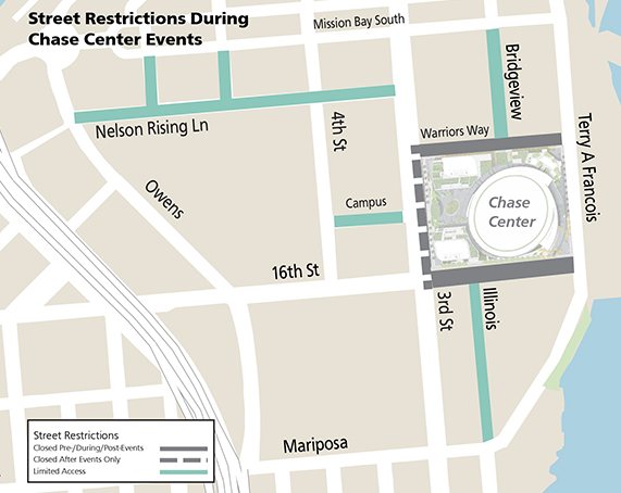
Event Day Street Closures (10,000+ attendance):
Chase Center:
- Two hours before until one hour after each event:
-16th St, between 3rd St and Terry Francois Blvd
-Warriors Way, between 3rd St and Terry Francois Blvd
-Northbound Illinois St, between Mariposa and 16th St, will be local access only - Additional street closure 30 minutes before until 45 minutes after each event:
-Northbound 3rd St, between 16th St and Warriors Way - MORE INFO
- View street closure map
Oracle Park:
- Two and a half hours before the opening pitch, the SFMTA will close eastbound King Street between 3rd and 2nd streets to vehicle traffic. King Street will reopen after first pitch until the seventh inning.
- From the seventh inning until post-game traffic dies down, the SFMTA will again close eastbound King Street between 3rd and 2nd streets to vehicle traffic in order to reduce congestion on city streets.
- Additionally, the northbound portion of the 4th Street Bridge (Peter R. Maloney Bridge) will be closed to all traffic except Muni, taxis and bicycles during the post-game period.
- MORE INFO
New BikeLink app for easy bike parking at BART Stations
The new BikeLink mobile app can be used instead of a pre-paid BikeLink card to access and pay for elockers:
- The app lets users put time on the meter and open the door to park their bike inside.
- BikeLink cards will continue to work.
- New users can start with a minimum of $5 on their BikeLink account.
- (BikeLink card balance and the BikeLink app balance are not connected.)
- elockers are available at 40 BART stations
Additional Resources: